
|
|
Lieutenant George Patrick Ahern
|
 |
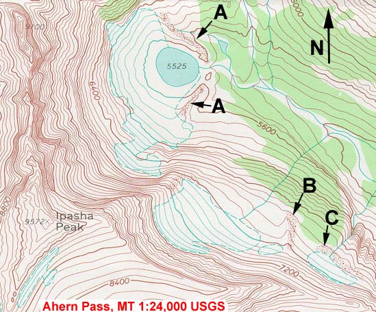
The Ahern Glacier can be seen from the Ptarmigan Tunnel Trail in Glacier National Park in Montana. The glacier, as well as Ahern Pass and Ahern Peak, were named by Lieutenant George Patrick Ahern who led an 1890 expedition to explore the area. |
"To the first visitors of the upper reaches of what is today known as the McDonald Valley, Heaven's Peak must have been an awesome, mysterious sight. It certainly was a surprise to the members of Lieutenant George Ahern's 1890 expedition.Approaching from the west, the jagged, razor-edged wall, now known as the Garden Wall was the dominant feature. At the point where they must have thought that they would be stopped by the Divide, the landscape suddenly opened up, revealing a much different mountain. Where they had been surrounded by peaks with narrow bases and steep cliffs leading up to narrow razor-ridges, they suddenly found themselves looking back across an open (though heavily vegetated) valley at a peak with a broad base, crowned in snow. It was not until they had moved well past Heaven's Peak that they became aware of its broad, snow-capped form. It was so different from what they had been seeing.
These explorers were certainly not the first people to see the mountain, but one of the members of that expedition, a prospector named Dutch Louie Meyer is credited with giving the mountain its name. This same peak was called "Red Bird" by the Kootenai, and "Where God Lives" by the Blackfeet. The members of this expedition, shared a common feeling that there was a mystical, mysterious quality to the area.
To all of those earlier explorers, this was a place of magical beauty. One must be cautious in such situations. Where there is great beauty, there is also the potential for malevolence and desolation. The deeper the magic, the greater the potential for terror."
— Firestorm! - The Story of the Heaven's Peak Fire of 1936 by Rolf L. Larson

Everything wet (which was . . . everything) froze in the night. But, the morning brought clear skies. The sun was taking over, and slowly, it marched down our shaded mountain valley. I shivered as the heat got closer — 100 yards, 50 yards . . . I couldn't wait, and ran into the light. I stood on a rock and basked like a lizard. We spent the next few hours drying our possessions in the ever-warming sun.Glacier was alive in the sun. The trail continued its mountainside traverse above the trees, snowy peaks rose from our feet to the horizon, and all places in-between. Giant waterfalls, hundreds of feet high, poured off mountainsides miles away - vertical white lines interrupting the green and grey carpet. We quickly arrived at the Ahern Drift.

“The Drift,” we had been warned, was one thing that could put a crimp on our blissful little romp through Glacier. The Drift was formed by snow that slid off a high north-facing slope. At the bottom, it formed an enormous pile of ice that rarely, if ever, melted. The trail was routed straight across it. There wasn't a good way to go around the drift either—it would mean miles of steep boulders and thick virgin forest. During the height of the summer, the park service actually shoveled out a path through the drift, but we were there before anyone that year, the drift was solid and untouched. We started across, at first able to sink our feet into the soft snow, then able to kick steps with a little more effort. As the slope got steep and icy, we had to chop steps with our ice-axes—chop out a level footprint, move your foot, chop out another, and so on... all the time keeping a good sense of balance and awareness. A slip would mean a steep slide down to some boulders hundreds of feet below. An ice axe might be able to brake a fall, but it was better not to fall in the first place. The last 15 yards of the drift were the stiffest and steepest—about a 60 degree slope. Then, we made it to solid ground. Looking back, we thought, that's it? Sure the drift was a little challenging, and we did need our ice axes, but, it didn't live up to the hype. As with so many things, the challenge was relative—compared to a walk to the K-mart, impossible—in the scope of a 2800 mile hike, it was a side-note.

| |||||
"Again, in 1890, another army detachment, under Lieutenant George P. Ahern, then stationed at Fort Shaw, was ordered to explore the mountains along the Canadian border. The party consisted of Ahern, a detachment of negro soldiers from the 25th Infantry, Professor G. E. [Garry Eugene] Culver of the University of Wisconsin, two experienced mountaineers (packer and guide respectively), two prospectors, two Indian guides, and the pack train. The party left Fort Shaw on August 5, crossed the prairies, and finally reached the foot of the mountains near Cut Bank Creek. From there they went north to the International Boundary, thence up the Belly River toward the pass that later was named for Lieutenant Ahern.Upon reaching this pass, the entire party worked for two days making a trail from the foot of the talus slope to the summit, completing the first of two known successful trips with pack stock over present Ahern Pass. (The second trip was by R. H. Sargent of the U. S. Geological Survey, in 1913.) Because the western slope of the pass was heavily timbered, they had difficulty cutting their way through; nor was this helped by the fact that most of the trip was accomplished in pouring rain.
Upon reaching McDonald Creek the Ahern party turned up the creek for some distance, then crossed over into Camas Creek Valley, probably in the vicinity of the present Heaven's Peak Lookout Trail. From there they traveled down Camas Creek (which he calls "Mud Creek" on his map) to the valley of the North Fork of the Flathead River, where they swung back toward Lake McDonald, presumably about the route of the present North Fork Truck Trail, and proceeded down the Flathead River to the Flathead Valley.
On this journey, side trips were made up Cut Bank Creek to the summit; up Swiftcurrent Valley or St. Mary Valley (the records are not clear on this), to the summit; and over the divide from McDonald Creek into the headwaters of the Waterton Valley. The complaints of some present-day "dude" parties about bad trail conditions seem silly in the face of the difficulties faced by these men who had to cut a route through a virgin forest and in many instances built trail to get their stock through. To fully appreciate this, one would have to attempt taking loaded pack stock cross-country from Ahern Pass to Camas Creek today — a feat that modern packers would term practically impossible!"
— Montana: The Magazine of Western History July 1957
|
The party.—In August, 1890, a small party of soldiers under the command of Lieut. George P. Ahern, of the Twenty-fifth infantry, was sent to explore the mountainous region in northwestern Montana. The party as finally made up consisted of two mountaineers, packer and guide respectively, two prospectors eager to take advantage of a new route to possible gold fields, two Indian guides, a squad of soldiers, black as ebony, the commanding officer, and the writer. All were mounted and well armed. Thirty days' rations were carried. It was supposed we would reach an outpost on the west side of the range in a month, to which point another thirty day's supply was sent. Owing to the assistance of various hungry natives and the keenness of mountain appetites our rations lasted but twenty days. Game of all kind was abundant, but the noise; made by the passage of such a party prevented very frequent additions to our larder from this source. A few ducks, grouse, and ptarmigan paid our "cook-house" a visit, as did numerous fine trout. Of large game, we secured one bighorn, and sixteen mountain goats. The young of the latter are very fine eating; the old bucks taste of musk. Notes on a Little Known Region of Northwestern Montana
by Garry Eugene Culver
INTRODUCTORY.
The region covered by the route lies between the 49th parallel on the north and the 47th on the south, and between 112° 30' and 114° 30' west. It is divided naturally into the following regions: 1. The western border of the plains, a strip 40 by 130 miles. 2. The narrow belt of foot-hills, four to twenty miles wide skirting the range. 3. The main range of the Rocky mountains, and 4. The Great Flathead valley with its tributaries. In the eastern portion of this region, well toward the national boundary, the Piegan and Blackfeet Indian reservations are located. In the southwestern portion is the Flathead Indian reservation, extending from Flathead lake down to the Northern Pacific railroad. With the exception of these agencies lying on the outer border of the region it is wholly uninhabited, and, so far as could be learned, almost wholly unexplored.
Object of the journey.—The object of the expedition was to find, if possible, a pass over the main range farther north than any then known, to map the course of the streams and the principal Indian trails. As such a trip might offer some opportunity for geological observation I accepted Lieut. Ahern's invitation to join him.
Region traversed.—We left Fort Shaw, Montana, on the morning of August 5th. Our route for the first ninety miles was over a rolling prairie, somewhat west of north, but gradually swinging more to the west, until at the end of the fourth day we went into camp in the foot-hills close up to the base of the main range on the Cut Bank Creek, thirty-five miles from the boundary. A fairly good wagon trail leads to this point, and our supplies had been so far transported by wagon. They were now transferred to the pack-mules, who entered a vigorous protest against this return to more primitive methods.
Our course from the Cut Bank was nearly north to the national boundary, which we touched first in longitude 113° 30' west. From this point we moved westerly to the valley of the Belly River, crossing the main range at the head of that stream about fifteen miles south of the boundary, in longitude 113° 40'. From the new pass we descended by the way of Mud Creek into the valley of the North Fork of Flathead river, our course being very crooked, but averaging about southwest by south. Our farthest west, 114° 45', was reached near the 48th parallel, at which point I left the party, returning home by the way of Flathead lake and south to the Northern Pacific railroad; We were eight days on the plains and twenty-two days in the mountains. Side trips were made as follows: Up the Cut Bank to the summit of the main range, where there is an easy pass at an elevation of 7,800 feet; up the Swift Current from the foot of St. Mary's lakes also to the summit, but a vertical descent on the western side, of many hundred feet barred further progress there. Another trip was made over the divide between MacDonald's Creek and the head waters of the East Kootanie to Glacier Creek. The whole distance traveled in saddle or on foot was estimated at 370 miles.PREVIOUS EXPLORATIONS. So far as I know, the only explorations in this region previous to our visit were by members of the Boundary Commission along the 49th parallel, and by Dawson, McConnell, and others of the Canadian Survey on the north side of the line. None of these, so far as I can find, traveled far south from the line in the mountains.GEOGRAPHY AND GENERAL DESCRIPTION. The plains.—The region lying east of the mountains from Fort Shaw to the boundary is a high prairie, sloping rapidly from west to east and traversed by occasional swift streams from the mountains. The elevations range from 5,000 feet at the base of the mountains to 3,500 at a distance of forty miles east. The Milk River Ridge, where we crossed it, rises several hundred feet above the streams that unite to form the South Fork of Milk River and over a thousand feet above the surface of St. Mary's Lake. This ridge has a nearly north and south trend near the boundary, but bears a little west of south and joins the main range on the upper waters of the Cut Bank. It is the water-shed between the Hudson Bay basin and the Gulf of Mexico. It was followed by Lieut. Ahern and myself to its junction with the main divide of the Rocky Mountains, and the separation was found to be so sharp that from the summit on the north side of the pass one might without moving from his tracks cast three snow-balls so that one would fall on the Pacific slope, another on the Gulf slope, and a third on that of Hudson's Bay.
The foot-hills.—The high prairie is separated from the mountains by a narrow belt, consisting of a somewhat confused mass of ridges and hills. The ridges constituting the foot-hills run in all directions, but the highest are approximately at right angles to the trend of the mountains. The strata are considerably disturbed being usually tilted more, and much more irregularly than the beds in the adjacent mountains. The elevation of these hills is usually under 1,000 feet above the plains, but sometimes runs up to 1,500 feet or more. The line separating the foot-hills from the mountains is quite as sharply drawn in this region as that between the plains and the foot-hills. The latter are usually wooded and somewhat rounded. The mountains, on the other hand, present a frowning battlement of bare and almost vertical walls facing the plain and rising 3,000 to 4,000 above it.
The mountains.—On entering the mountains by way of the valley of the Belly River we found that the range makes a sharp bend to the west about twenty miles from the boundary, so that, although we were now traveling nearly south, we were approaching the main divide nearly at right angles to it. The valley is over a mile wide near the boundary, but a short distance up the stream it becomes quite canyon-like. The walls are very steep and rarely less than 2,000 feet high. We went into camp just at the lower end of the canyon, in a dense fog which shut out from view all objects a hundred yards away. In the morning when we looked out of our tents the fog was slowly drifting away and glimpses of the lofty peaks could be had through rifts in the fog. The effect was quite striking. The foot of the mountains was entirely concealed, but at our camp some two miles away the air was clear. Now and then a projecting portion of a mountain side perhaps 2,000 feet above us would be clearly revealed, while above and below the white fleecy veil hid all and seemed to have taken the mountain up bodily and to be about to remove it from our pathway. In other places the upper peaks alone rose clear and distinct above the sea of cloud and seemingly almost over our heads. Altogether it was a picture long to be remembered by those who saw it.
Scenery.—The scenery even along the foot-hills is strikingly beautiful. The lower ridges, rounded and tree-covered, rise abruptly from the plains, while as a background the bare rocky walls of the mountains cut by transverse valleys rise in stately grandeur. A single glance takes in a view of level plain, tumbled foot-hills, and lofty mountains, the latter softened somewhat in their outline by distance. As the summit of the main range is neared plains and foot-hills disappear and the landscape is made up only of rocky mountains lifting their jagged summits above deep narrow valleys down which swift torrents, from the snow-fields and small glaciers above, roar and tumble over their rocky beds, or plunge from ledge to ledge in beautiful cataracts. At intervals in these valleys the falling debris from the canyon walls has dammed the stream and beautiful lakes are formed. The river we ascended takes its rise in one of these lakes, lying in a beautiful amphitheatre at the very foot of the continental divide. The lake is about two miles long and a mile wide. It is supplied wholly by three small glaciers which cling to the side of the mountain 2,000 feet above it. The amphitheatre contains about eight square miles. It is the result of a loop-like bend in the dividing ridge. Its walls are almost vertical, save one portion on the southeast side, and are from 2,000 to 3,500 feet high. The new pass is at the head of this amphitheatre, 7,250 feet above sea.[It was here that the services of our Indian guide came in play. One of the prospectors with us had three years before camped at this very spot with three other men and had tried for a week to find some means of scaling the rocky wall which barred their way. They were used to the mountains, but were obliged to give up and retrace their steps.] The dividing ridge itself the backbone of the continent, is surprisingly narrow and quite sinuous It is terminated at the summit by a thin wall varying from 50 to 300 feet in thickness and surmounted by pinnacles and chimneys which emphasize its wall-like appearance. It is in many places so narrow and rugged that it would be impossible to travel along it without the use of ropes and ladders. It preserves this peculiar mural character for at least 50 miles.
Ahern Pass.—Ahern Pass is 2,000 feet above the lake at its foot, and the summit wall on either side of the pass was estimated to be at least 1,500 feet more. The entire force had worked two days in making a trail from the foot of the talus slope to the summit of the pass. The assent is very steep and was made with difficulty. ["Aug. 22. As I led the pack-train out this morning I felt extremely anxious as there were several places on the trail where a misstep meant certain death. At the north end of the lake the trail zig-zags up a very steep grassy slope for 800 feet and then over loose slide-rock—talus—for 1,100 feet higher to the cut-walls, which loom up 2,000 feet above the slide-rock. The trail now follows narrow ledges straight for the gap, which is on the same level and 500 yards west. At one place we climbed a narrow and very steep rock fifteen feet high, in which we had to cut steps. We led our most troublesome animals over this. My feelings were indescribable when I started up this rock, not knowing what the horse would do. The ledge was about eighteen inches wide, the upside wall sloping back. On the lower side was a fall of 1,900 feet."—From Lieut. Ahern's official report.]
The Western Slope.—The western slope is in strong contrast with the eastern. A gentle grassy declivity, down which we could indulge in the rare luxury of riding, stretched away for a couple of miles, after which it rapidly became steeper, following the changing dip of the strata, until we were obliged to dismount and lead our horses through the thick tangle of brush with which the steeper slopes were covered. We passed the summit in a biting wind accompanied by rain and sleet, with a temperature of 39°. As we descended the rain increased. We marched in single file through the dripping beech brush, halting every few yards for the axemen to cut a trail. Sometimes we could travel for a few rods in the bed of the stream. Then obstructions in the form of cascades or huge rocks would compel us to cut a path up the steep banks and pursue our course along the sloping sides of the valley. The descent grew constantly steeper and our progress correspondingly difficult and slow. For four hours we toiled along in this fashion, every hundred yards in advance bringing us to greater difficulties. At last, wet to the skin, our teeth chattering with cold, and thoroughly worn out, we cleared a place large enough to put up our tents and went into camp. What a luxury a fire is under such circumstances! We had eaten an early breakfast at the foot of the lake on the other side. Since that time we had been working incessantly, most of the time in a pouring rain, until five o'clock in the afternoon found us in the condition described, two and a half miles down the Pacific slope in a dense tangle of fallen logs, thickly overgrown with brush. We had our supper, warmed ourselves, and were fairly comfortable in a couple of hours, but there was nothing for the horses to eat and we were obliged to tie them to the trees for the night. The next morning they were taken back a mile on the trail to the last grass we passed, where they were pastured for a couple of days while the men cut a trail two miles to the more open country in the valley below.
A side trip.—Leaving the main party here to rest for a few days, Lieut. Ahern and myself with the prospector, Lewis Meyer, made a four days' trip up MacDonald's Creek and over the divide to the headwaters of a branch of the East Kootanie. Our purpose was to examine the large glacier described in another portion of this paper. The route lay across a succession of ridges, ranging in elevation from 500 to 2,700 feet above their respective valleys. The lower slopes are densley [sic] wooded and fallen timber added to the work of climbing. The summits of all except the highest ridges were quite level grassy parks, with borders and patches of pines. From any of these summits a magnificent view was to be had of the great backbone over which we had climbed. Fifty miles of it could be seen at once owing to the great bend it makes to the westward.
On our return trip we endeavored to shorten our route by taking a short cut over the summit of a spur of the main range. This took us up 8,000 feet. A rapid descent of 2,000 feet was then made, and the first part of the cut off had been successfully accomplished. After a couple of miles of easy going we started on another descent of 2,000 feet into the valley of MacDonald's Creek. We found the descent extremely difficult. It was so steep that we kept our feet with difficulty. Impassible ledges were frequently in our way and multitudes of fallen trees encumbered the less precipitous slopes. We were three hours making the first half mile. Darkness came on while we were still three miles from camp and we spread our blankets on the stony banks of the stream and lay down to wait for daylight. We had eaten the last of our rations at noon, expecting to reach camp that evening. We started on at 6 A. M., and at 10:30 rode into camp and ordered dinner.
We were now not more than eight miles from the large glacier elsewhere mentioned, and I was eager to visit it. But travel in this region is indescribably difficult; we had spent four days in the side trip I have just described, our rations were nearly gone, and we had yet nearly a hundred miles to go before we could reach our base of supplies. It was therefore plainly evident that we must move on and leave this most attractive region, in the hope that at some future time fortune may be more kind.
Mud Creek.—Our route now was down the valley of Mud Creek to the north fork of the Flathead. This stream, Mud Creek, flows between steep rocky walls from 1,500 to 2,000 feet high. They gradually grow less precipitous and the valley widens as we descend. The lower portion of the valley has been covered with a thick growth of pines. In the winter avalanches sweep down the steep slopes on either side and towards the bottom carry everything before them; not a stick or a stone is left. The debris thus accumulated is hurled into the bed of the stream and in some cases permanent dams have been thus made and lakes formed. Some of these have in the lapse of time become marshes stretching clear across the valley. These marshes are soft and miry for pack animals, hence the name Mud Creek. The existing lakes are half full of the slowly decaying trunks of the pines swept into them. A great mass of trees, earth, stones and snow, the remains of an avalanche of the previous winter still lay at the foot of one of the many wide swaths cut through the pines, a silent but eloquent witness of the destroying work of the snow.
Flathead Valley.—The great Flathead valley, although deeply eroded, is not a valley of erosion, but is a good example of a synclinal valley. It is a deep trough between the Rocky Mountain range on the east and the high ranges to the west. Its character will be seen when it is stated that if a line be measured from the summit of the Rockies to the Flathead valley, and another an equal distance out to the plains eastward, the elevation of the point on the plains will be found to be from 1,000 to 2,500 feet higher than the corresponding point in the Flathead valley. The same is true of the great Columbia-Kootanie valley of British Columbia. Dense forests of pine, spruce, hemlock, etc., crowd the valley of the Flathead and those of its tributaries on the east down nearly to Flathead lake. Here on the prairie-like openings a few ranches have been established. . . . [The article continues with several pages of notes on the geology of the region.]— Notes on a Little Known Region in North-Western Montana by Garry Eugene Culver, published in Transactions of the Wisconsin Academy of Sciences, Arts, and Letters (1892).
"The ROTC program started at Montana State University in 1896 with a parade of 40 cadets participating in a ceremony during which the Governor of Montana laid the cornerstone of Montana Hall. Professor William M. Cobleigh was the first Professor of Military Science, in addition to his primary job of college professor. Army Lieutenant George P. Ahern arrived shortly thereafter, and served as the PMS during 1897 and 1898. During this period the ROTC Department received the Model Springfield rifles and two artillery pieces. Lt. Ahern taught courses in basic Military Science and Tactics and insured that all cadets fired all military weapons available.At the outbreak of the Spanish-American War in 1889, Captain (newly promoted) Ahern was called back to Regular Army service, leaving a void in ROTC instructors at MSU for 18 years."

"Officers did not have to find themselves stationed at universities to partake of the educational opportunities available in many urban areas, and the ways officers became involved in civilian communities were as varied as the personalities of the individuals concerned. Pershing's friend and classmate, Avery D. Andrews, attended law school in Washington, D.C., while on assignment with the War Department, and George P. Ahern, on recruiting duty in the East, enrolled in the senior class of the Yale Law School, completing a thesis on "The Necessity for Forestry Legislation" before returning to his regiment in Montana, where he used whatever spare time he could muster to spread the gospel of conservation before representatives of mining and lumbering interests. Even isolation in Montana did not prevent Ahern from maintaining contact with influential foresters in the East such as Gifford Pinchot and Bernard Fernow."— The U.S. Army and Irregular Warfare: Progressives in Uniform by John M. Gates
Said Takes-Gun-Ahead to me this afternoon: "Who are these white men for whom the mountains were named? Were they great warriors, or presidents, or wise men?" I had to confess that I had never heard of them. "Huh!" he exclaimed. And "Huh!" all the others, even the women echoed.— Blackfeet Tales of Glacier National Park by James Willard Schultz
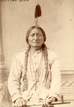
 Sitting Bull and his family at Fort Randall |
[Major] George P. Ahern, 25th Infantry, in charge of Sitting Bull's mail, describes him as "a very remarkable man — such a vivid personality . . . square-shouldered, deep-chested, fine head, and the manner of a man who knew his ground. He looked squarely into your eyes, and spoke deliberately and forcefully. . . . For several months I was in daily contact with Sitting Bull, and learned to admire him for his many fine qualities. |
"Ever since 1882 there has been gross and continuous mismanagement of Indian affairs. . . . This able, brilliant people was crushed, held down, moved from place to place, cheated, lied to, given the lowest types of schools and teachers, and kept always under the heel of a tyrannical Bureau." — Lieutenant Colonel George P. Ahern, U. S. A., Retired | |
|

Company B, 25th Infantry at Fort Shaw, Montana 1888
"In April, 1880, the regiment was ordered to the Department of Dakota, exchanging with the 1st Infantry. Headquarters and four companies took station at Fort Randall, S. D., in June and remained there until the arrival of the 15th Infantry in November, 1882, when they were transferred to Fort Snelling, Minn., relieving the 7th Infantry. During this period four companies were stationed at Fort Meade, S. D., and two at Fort Hale, S. D. The latter post was abandoned in May, 1884, and the garrison transferred to Fort Sisseton, N. D.In May, 1888, the regiment was transferred to Montana, exchanging stations with the 3rd Infantry. Headquarters and four companies were located at Fort Missoula, while four companies went to Fort Shaw and two to Fort Custer.
In September, 1890, companies I and K were skeletonized pursuant to orders from the War Department. Lieutenant-Colonel Van Horn, with companies C, E, F and H, arrived at Fort Keogh the last of November, 1890, and remained there in camp until February 5, 1891, when they returned to their stations, nothing further having been required of them during that short but eventful campaign against the hostile Sioux.
—Twenty-Fifth Regiment of Infantry by Lieut. George Andrews
"Complaints by the men of the black infantry regiments that certain officers mistreated them did occur, and it is difficult to determine by the evidence available whether actual mistreatment existed in each case. One example was an anonymous letter sent to the Secretary of War in 1888 alleging that officers at Fort Shaw, Montana Territory, were prejudiced against black soldiers. The anonymous letter, written a few days after the lynching of Private Robert Robinson [by a mob who took him from a civilian jail where he was being held for shooting a local citizen], stated that the commanding officer, Lieutenant Colonel J. J. VanHorn, had released Private Robinson to civilian authorities knowing there was a good chance he would be lynched. The unknown author also stated that the commanding officer had openly declared his dislike for blacks and treated them as if they were still slaves. Whether this complaint was based on fact or frustration over the event to which it was related cannot be determined. But at least one officer at Fort Shaw who was directly involved in turning Private Robinson over to civil authorities did at a later time exhibit a condescending attitude towards blacks. While on bivouac with the Twenty-Fifth Infantry near Fort Keogh, Montana, during the Pine Ridge Campaign, Lieutenant G. P. Ahern wrote a local newspaper:We have a strong force of infantry and cavalry here on the northwest corner of the war. Our 'cullud' battalion here is under canvas and in fine shape for a winter campaign, and when Jack Frost freezes the mercury out of sight the gay and festive coon will be found ready to dance the 'Virginia essence' and sing as joyfully as ever." — Stock Growers Journal (Miles City, Montana) December 17, 1890— The Black Infantry in the West, 1869-1891 by Arlen L. Fowler
PALO ALTO, Puerto Principe Province, Cuba, July 8, 1898. |
On the night of June 30th, the Rough Riders began preparations for the long-awaited assault to take Santiago that would commence the following morning. The men of the Tenth Cavalry had already distinguished themselves in the battle at Las Guasimas, and would further add to their glowing traditions on the following day. But in the day preceding the assaults on San Juan Hill and El Caney, four members of the 10th Cavalry were making history miles away on the small island of Cuba. |
|
|
| ||||||||||||||||||||
|
| ||||||
|
|
|
This page copyright © 2000-2010 by Dennis Ahern.
visitors have
accessed this page since June 4, 2000.
This page was last updated 15 August 2010.


