
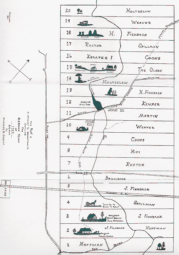
The first map is entitled "The Plat of the German Town of 1729." It shows the land holdings of Holtzclaw, Weaver, Fishback, Spillman, Coons, Kemper, Martin, Hoffman, Rector, and Brumback.
The second map is entitled "A Map of the First Patents of Land in Madison County, Virginia, as of the Year 1740."
The third map shows Patents to the West and South of the first Map, and includes, among others, Patents of King, Eddings, Holt, Batteley, Rucker, Taliaferro, Cave, Phillips, Rice, Dougharty, Bruce, and John BROYLES (Johannes BREYHEL).
=========================
The dimensions of the first graphics file are 630 x 896 pixels; its size is 136,955 bytes.
The dimensions of the second graphics file are 3133 x 2341 pixels; its size is 185,266 bytes.
The dimensions of the third graphics file is 3171 x 2463 pixels; its size is 138,143 bytes.
(The maps you see here are reduced in size to make it easier to see the entire maps, and take less time to load. (Viewing these reduced-size graphics isn't very satisfactory.)
These maps were produced by John Blankenbaker and are copyrighted by him.
If you wish to view the full-size map, LEFT-click on the graphic and the full sized picture will load on a new page. (The resulting maps are quite large, so you will have to use the scroll bars to see the entire maps. The reason for such large size is to maintain the high resolution of these maps. For optimum viewing, you should download them and use your graphics viewer to resize them.)
To download a file, once you are viewing it in full-view, right-click on the image and choose "Save to Disk", "Save Image As", or whatever choice your web browser gives you. Do not attempt to download from the reduced images on this page.
To print and retain the high resolution (720 dpi) keep the file at its present size and use "Page Setup" in your graphics viewer to "center" the printout, "maintain aspect ratio", and "use full page".
(Click on the "Photos Home Page" at the bottom of this page to find links to other "Germanna Photos" pages, and to find out how to submit your Germanna photos for inclusion here. Also, please read the instructions for sending the photos or graphics files to me.)
This page shows three maps of Land Patents in Madison County, VA. These Patents were obtained by members of the 1st and 2nd Germanna Colonies.
Map # 1
The Plat of the German Town of 1729
Map # 2
A Map of the First Patents of Land in Madison County, Virginia,
as of the Year 1740
Map # 3
Patents to the West and South of Map # 1
![]()
![]() Go To Top.
Go To Top.
![]()