
The Boone County, KY, Planning Commission, in conjunction with the Johnson-Wilson Cemetery Stewards Association, has produced a map of all the known cemeteries in Boone County. Funding for this project was provided by the Kentucky Cemetery Preservation Fund and R. C. and Deborah Jo Durr.
(I received the map by calling the Main Boone Co. Library in Burlington and asking for the Historical Department. The nice lady there mailed me the map free of charge. THANK YOU! As a note, her mother was a WILHOIT!)
The address for the Library is:
This map includes most of the known private family cemeteries in Boone County. Some of these are on private property, and several are located on the property of the Cincinnati/Northern Kentucky International Airport. Some of the latter are actually right beside runways of the airport! (As one person at the July 2009 "Germanna Reunion" in Culpeper Co., VA, told me, be aware that those little plots of land between the runways, where the gravestones are now located, may not indicate the "actual" location of the graves. The contractors for the building of the runways may have "slightly moved" the gravestones in those family plots a "little" to one side or another to accomodate the location of the runways. In any case, the actual graves are "fairly" close to where the gravestones are now located. [GWD]
The map has been so helpful in locating obscure cemeteries that I thought it worthwhile to scan it and post the results here. It is a large map and if you wish to print it, you should use 8.5 in. x 14.0 paper. (The Index will print fine on 8.5 x 11.0 paper.)
I have copied the map and the index for the location of the cemeteries. Below are clickable thumbnails for the two files. DO NOT download the thumbnails; instead, left click them to open up full-sized images, which you can them download.
DO NOT try to print from the opened images on the website. Download the images and then use your graphics program to print from.
Main Branch
Boone Co. Public Library
1786 Burlington Pike
Burlington, KY 41005-9557
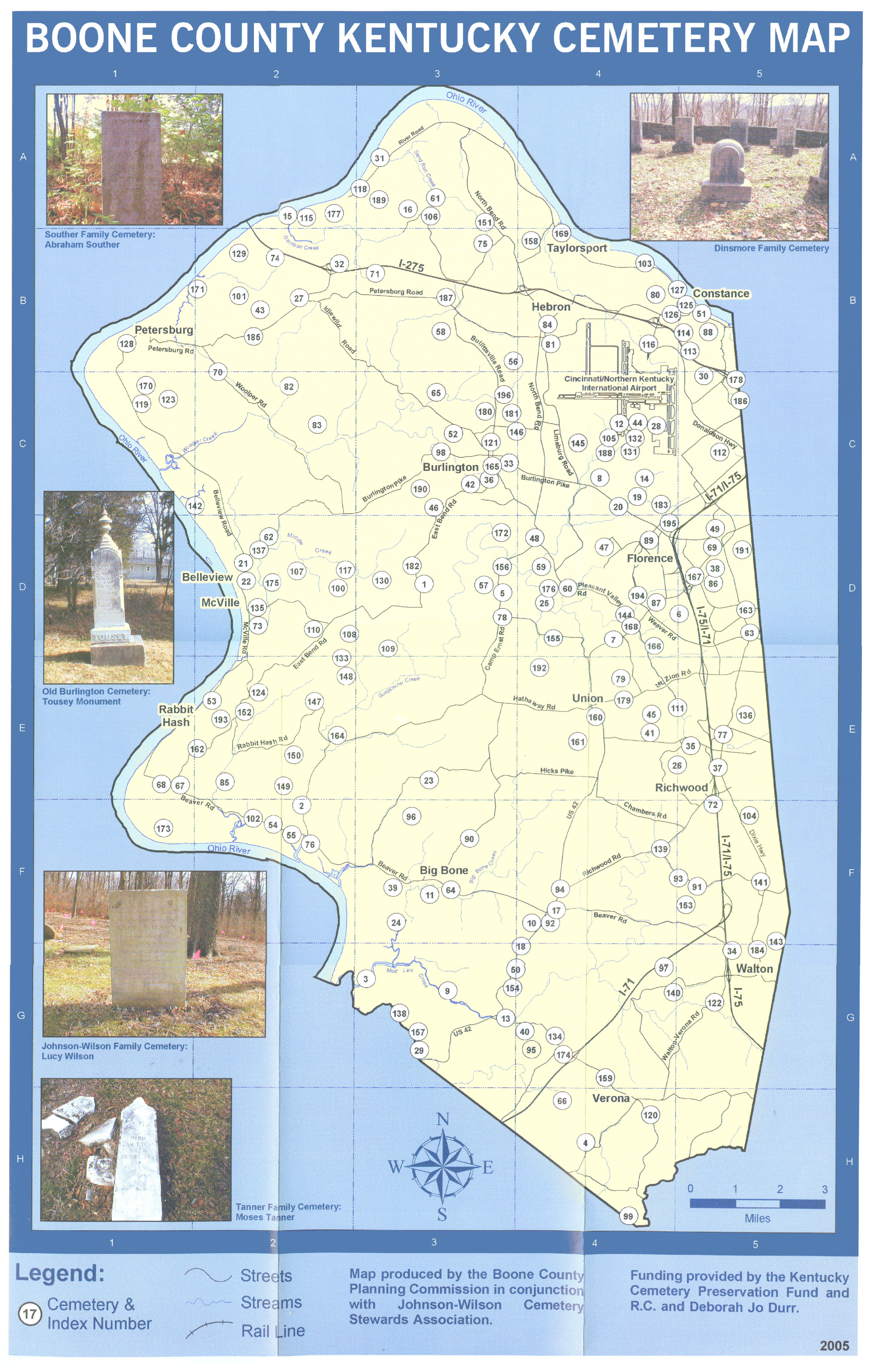 Boone Co., KY, Cemeteries Map |
 Boone Co., KY, Cemeteries Map Index |
No. 8:
The W. Aylor (William Aylor) Family Cemetery is located in Limaburg, just off Burlington Pike.
No. 12:
The Baker-Rouse Family Cemetery, now near a runway of the Cincinnati/Northern Kentucky International Airport.
No. 21 & No. 22:
Both cemeteries are located in Belleview, on the Belleville Rd. The Old Belleview Cemetery was used until 1903, when the Belleview Baptist Church was built. Anyone buried prior to 1903 will be in the Old Belleview Cemetery; anyone buried after 1903 will be in the Belleview Cemetery.
No. 32:
The Bullitsburg Baptist Church Cemetery is located near Idlewild, off Interstate I-275.
No. 33:
The Burlington (Burlington I.O.O.F) Cemetery is located in Burlington, just off Burlington Pike.
No. 38:
The Rev. Wm. Carptenter Family Cemetery is located near Florence.
No. 48:
The Clore-Weaver Family Cemetery is located on Mark Cook's Place, on Camp Ernst Rd., between Burlington and Florence.
No. 68:
The East Bend Methodist Church is located SSE of Rabbit Hash, on Beaver Rd.
No. 145:
The E. Rouse (Elijah Rouse) Family Cemetery is located near a runway of the Cincinnati/Northern Kentucky International Airport.
No. 168:
The Tanner-Utz (Ephraim Tanner) Family Cemetery is located off Pleasant Valley Rd., SSE of Florence.
No. 151:
The Sand Run Baptist Church Cemetery is located at Francisville, just off North Bend Rd.
No. 158:
The Souther Family Cemetery is located near Taylorsport.
No. 188:
The Weaver Family Cemtery is located on Limaburg Creek Rd., 1 mi. NE of Limaburg.
Not listed on the map or the Index are the following:
1. A Delph Family Cemetery, located near Limaburg (near the Cincinatti/Northern Kentucky International Airport). This is not the Delph Family Cemetery (No. 60) located SW of Florence.
2. The William Eli Carpenter Family Cemtery, located east of Union. This is a different cemetery from the other "Carpenter" cemeteries on the map (Nos. 37, 38, & 39).
3. The Murdock Cemetery, located south of Burlington.
4. The Presbyterian Church Cemetery, located in Richwood.
5. Another Tanner Family Cemetery, located NE of Hamilton, near Gunpowder Creek.
6. The Union Cemetery, located in Union.)
I think that just about all of these Boone Co. cemeteries have one or more Germanna descendants buried there. I know that those I have listed above do. If you need help finding the exact locations of other "Germanna" cemeteries in Boone Co., please feel free to email me at [email protected].
(Webmaster: SgtGeorge, George W. Durman.)
I have located the exact locations of some of these cemeteries, that is, the names of the roads on which they are located, their distance from the closest towns/communities, etc. I will try to add those locations to this web page as I get time to do so.
![]() [Back to Germanna Colonies Family History Home Page.]
[Back to Germanna Colonies Family History Home Page.]